


 24/7 Emergency Service
The 2021 Atlantic Hurricane Season Is Upon Us
5/6/2021 (Permalink)
 A recent forecast anticipates an above-average probability for major hurricanes to make landfall along the United States coastline.
2021 Atlantic Hurricane Season Forecast
Predictions so far forecast a milder season than last year, but still a very active one. Reading these predictions for 2021 will give you the ability to prepare.
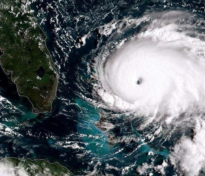
2020 Hurricane Season
The 2020 Atlantic hurricane season was one of the worst on record. There were 30 named storms, the highest number ever recorded. Meteorologists switched to Greek after exhausting the 21 letters of the English alphabet that are used in naming hurricanes. Also battering the coast that year were an extraordinary 13 hurricanes, with 6 that fell above a category 3.
For context, the average year has 12 named storms, six hurricanes, and three major hurricanes. A storm considered a major hurricane, higher than a category three, will have recorded winds at 115 miles per hour or higher. Category five hurricanes have wind recorded at 157 mph or higher. Comparatively, tropical storms have sustained winds of 73 mph, and regular hurricanes will have sustained winds of 74. The 2021 hurricane season starts on June 1st and lasts all the way until November, and the typical month with the most hurricanes is September--but the strongest ones usually occur in July and August.
Why Are Hurricanes Seasons More Active In Recent Years?
One of the reasons for more active seasons in recent years is global warming. A hurricane is created when high-pressure air combines with low-pressure air over warm waters, heating the moisture in the air. That warm low-pressure air then warms the high-pressure air, and the air begins to rise. As this air rises, it cools off. So in order for a hurricane to form, you need low air pressure, warm, humid ocean air, and wind. This creates the large storm clouds and front characteristics of a hurricane and gives it the steam to continue to build as it moves through warm waters. Hurricanes cool off as the water gets colder, which is why most hurricanes stay in tropical waters.
However, due to global warming, the greenhouse effect is warming waters further still, essentially sending a blast of energy through these hurricanes. Global warming causes not only warmer waters around the equator but increased precipitation and stronger winds.
What To Expect This Year
Various meteorological agencies have already released their forecasts, with NOAA's being the highest at 13-20 named storms and an average of 6-10 hurricanes with 3-5 of them being strong hurricanes of a category 3 or higher. Colorado State also made some predictions, forecasting 17 named storms, eight hurricanes, and four major hurricanes. That would make 2021 the sixth consecutive above-average hurricane season.
Florida
The Sunshine State is always in the spotlight during the Atlantic hurricane season, as the gulf maintains typically warm waters and the panhandle is usually right in the center of the projected paths of storms formed at the equator. Colorado State projects a 45% chance that a hurricane will hit the eastern US coast this season, including the Florida panhandle. The average chance of this in any given hurricane season is 31%, a significant difference. They also project a 69% chance of a hurricane hitting any part of the US coast (average 52%) and a 44% chance of a hit anywhere from the Florida panhandle to the Texas coast (average 30%).
So there is a higher-than-average chance that some part of Florida will see hurricane action this year. In order to understand the probability of where the hurricanes might hit, we can look at the historical records of where hurricanes have hit Florida in the past.
Northwest Florida, situated on the state's panhandle has suffered a total of 66 hurricanes, including 14 over a category 3. Because this region is technically outside the tropical zone, temperatures are lower, which creates that contrast in pressure that fuels warm-weather storms. It is interesting to note that all of the category 4-5 hurricanes that hit northwest Florida occurred after 2018; between 1815 and 2017, all of northwest Florida's major hurricanes were category 3.
The second-most hit region of Florida is the southeast with 44 hurricanes on record. This area of Florida has endured seven category 4 hurricanes, as many as the entire state of Texas.
Northeast Florida has had 26 total hurricanes, making it third on the list. The safest areas in Florida are the most inland because hurricanes nearly always lose steam and energy when they hit land, and the more inland an area is, the more time the hurricane has to cool off. This is why coastal areas typically suffer the most damage.
As you can see from these statistics and predictions, elevated hurricane seasons are not likely to calm down--although we may see a less turbulent season than that of last year. Northwest Florida is likely to see the most action, with the Southeast second-most likely. Depending on where you live, these statistics can help you prepare for this year's hurricane season.